Geolocate

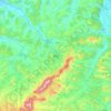
Hereclean topographic map

Click on the map to display elevation.

About this map

Name: Hereclean topographic map, elevation, terrain.

Location: Hereclean, Sălaj, Romania (47.18315 22.92763 47.33013 23.07120)

Average elevation: 267 m

Minimum elevation: 178 m

Maximum elevation: 503 m

Other topographic maps

Click on a map to view its topography, its elevation and its terrain.

Bădăcin

Romania > Sălaj

Average elevation: 278 m

Valea Loznei

Romania > Sălaj

Average elevation: 413 m

Jac

Romania > Sălaj

Average elevation: 282 m

Treznea

Romania > Sălaj

Average elevation: 369 m

Zalău

Romania > Sălaj

The city includes a total surface of 90.09 km2 (34.78 sq mi). This includes the one village it administers, Stâna (Felsőnyárló), situated south-east of Meseș, in the hydrographic basin of the Agrij River. Măgura Stânii is at an altitude of 716 m (2,349 ft).

Average elevation: 321 m

Var

Romania > Sălaj > Jibou

Average elevation: 238 m

Baica

Romania > Sălaj

Average elevation: 313 m

Ciglean

Romania > Sălaj

Average elevation: 300 m

Turbuța

Romania > Sălaj

Average elevation: 245 m

Zalău

Romania > Sălaj

The city includes a total surface of 90.09 km2 (34.78 sq mi). This includes the one village it administers, Stâna (Felsőnyárló), situated south-east of Meseș, in the hydrographic basin of the Agrij River. Măgura Stânii is at an altitude of 716 m (2,349 ft).

Average elevation: 321 m

Moigrad-Porolissum

Romania > Sălaj

Average elevation: 366 m

Zalău

Romania > Sălaj

The city includes a total surface of 90.09 km2 (34.78 sq mi). This includes the one village it administers, Stâna (Felsőnyárló), situated south-east of Meseș, in the hydrographic basin of the Agrij River. Măgura Stânii is at an altitude of 716 m (2,349 ft).

Average elevation: 317 m
Mal

Romania > Sălaj

Average elevation: 388 m

Adalin

Romania > Sălaj

Average elevation: 401 m

Tihău

Romania > Sălaj

Average elevation: 250 m

Husia

Romania > Sălaj > Jibou

Average elevation: 246 m

Fabrica

Romania > Sălaj

Average elevation: 357 m

Stana

Romania > Sălaj

Average elevation: 477 m

Bic

Romania > Sălaj

Average elevation: 318 m

Moigrad-Porolissum

Romania > Sălaj

Average elevation: 366 m

Mesteacănu

Romania > Sălaj

Average elevation: 453 m

Cozla

Romania > Sălaj

Average elevation: 417 m

Gear up for your next adventure:

🍽️Titanium Camping Spork - Ultralight and indestructible eating utensil
🥾Trekking Poles - Adjustable trekking poles to reduce knee stress and improve stability
⛺Camping Essentials - All-in-one gear for a comfortable camping trip
🚲Handlebar Phone Mount - View topographic-map.com live while cycling
🦟Insect Repellent - Keep mosquitoes and black flies away in wooded areas

As an Amazon Associate, this site earns from qualifying purchases at no extra cost to you.