Geolocate

Vilamouro topographic map

Click on the map to display elevation.

About this map

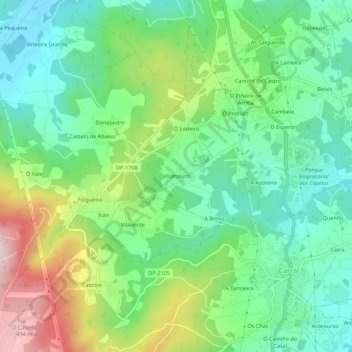
Name: Vilamouro topographic map, elevation, terrain.

Location: Vilamouro, Tabeaio, Carral, La Coruña, Galicia, 15182, España (43.22039 -8.39343 43.26039 -8.35343)

Average elevation: 185 m

Minimum elevation: 48 m

Maximum elevation: 464 m

Gear up for your next adventure:

🧼Biodegradable Camp Soap - Environmentally friendly cleaning for gear and body
💧Hydration Bladder - Hands-free hydration solution for long treks
🧥Insulated Jacket - Keep warm in cold outdoor conditions
🥾Waterproof Trail Shoes - Shoes designed to handle wet terrain
🥾Light Hiking Boots - Lightweight and comfortable boots for day hikes

As an Amazon Associate, this site earns from qualifying purchases at no extra cost to you.