
Alpine topographic map
Click on the map to display elevation.
About this map
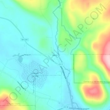
Name: Alpine topographic map, elevation, terrain.
Average elevation: 398 m
Minimum elevation: 338 m
Maximum elevation: 555 m
Other topographic maps
Click on a map to view its topography, its elevation and its terrain.
Finger Lakes National Forest
United States > New York > Schuyler County > Town of Hector
Average elevation: 356 m
Watkins Glen State Park
United States > New York > Schuyler County > Watkins Glen
During the Pleistocene era, a vast area was covered by ice during the maximum extent of glacial ice in the north polar area. The movement of glaciers from the Laurentide and Wisconsin ice sheets shaped the Finger Lakes region. The lakes originated as a series of northward-flowing streams. Around two million…
Average elevation: 392 m
Lamoka Lake
United States > New York > Schuyler County > Town of Tyrone > Weston
Average elevation: 351 m
Finger Lakes National Forest
United States > New York > Schuyler County > Town of Hector
Average elevation: 356 m