
Make a donation
Gear up for your next adventure:
As an Amazon Associate, this site earns from qualifying purchases at no extra cost to you.
Morrow Mountain topographic map
Click on the map to display elevation.
Make a donation
Gear up for your next adventure:
As an Amazon Associate, this site earns from qualifying purchases at no extra cost to you.
About this map
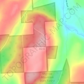
Name: Morrow Mountain topographic map, elevation, terrain.
Location: Morrow Mountain, Madison County, New York, United States (42.81234 -75.75100 42.81244 -75.75090)
Average elevation: 575 m
Minimum elevation: 475 m
Maximum elevation: 651 m
Make a donation
Gear up for your next adventure:
As an Amazon Associate, this site earns from qualifying purchases at no extra cost to you.
Other topographic maps
Click on a map to view its topography, its elevation and its terrain.
Make a donation
Gear up for your next adventure:
As an Amazon Associate, this site earns from qualifying purchases at no extra cost to you.
Make a donation
Gear up for your next adventure:
As an Amazon Associate, this site earns from qualifying purchases at no extra cost to you.
Village of Hamilton
United States > New York > Madison County
Northeast of Hamilton is Payne Brook, which starts at Lake Moraine and travels through the village before converging with the Chenango River. The elevation of the village's municipal airport (Hamilton Municipal Airport) is approximately 1,100 feet (340 m) above sea level.
Average elevation: 386 m