
Damascus topographic map
Click on the map to display elevation.
Damascus
As an unincorporated area, Damascus' boundaries are not officially defined. Damascus is recognized by the United States Census Bureau as a census-designated place, and by the United States Geological Survey as a populated place located. Damascus proper is a locally high spot at 847 ft (258m) above sea level, while other portions of the area described as Damascus are as high as 866 ft (264m) above sea level. Due to a quirk in the layout of Montgomery County, the highest elevation in the county is actually within what is considered Mt. Airy, MD, measuring 883 ft (269m) above sea level at the Full Gospel Church. This peak just southwest of Mt. Airy is actually the highest elevation in the immediately adjacent Washington D.C. suburbs and is located inside an often overlooked strip of Montgomery County which is approximately 1 mile (1.6 km) long and of varying width, generally a few hundred feet (~100 M) wide. While the Full Gospel Church building is within Montgomery County, the driveways are in Frederick County and portions of the parking lot are in Howard County.
About this map
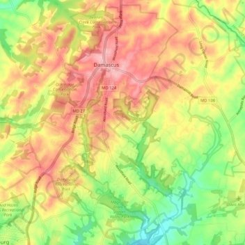
Name: Damascus topographic map, elevation, terrain.
Location: Damascus, Montgomery County, Maryland, 20872, United States (39.22915 -77.23627 39.30973 -77.15600)
Average elevation: 195 m
Minimum elevation: 122 m
Maximum elevation: 260 m
Other topographic maps
Click on a map to view its topography, its elevation and its terrain.
Clearspring Manor
United States > Maryland > Montgomery County > Damascus > Clearspring Manor
Average elevation: 215 m