Geolocate

Mabasa topographic map

Click on the map to display elevation.

About this map

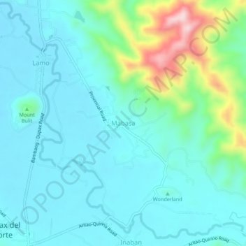
Name: Mabasa topographic map, elevation, terrain.

Location: Mabasa, Nueva Vizcaya, Cagayan Valley, Philippines (16.30468 121.10225 16.34468 121.14225)

Average elevation: 402 m

Minimum elevation: 336 m

Maximum elevation: 674 m

Other topographic maps

Click on a map to view its topography, its elevation and its terrain.

Kasibu River

Philippines > Nueva Vizcaya > Kasibu

Average elevation: 866 m

Kayapa

Philippines > Nueva Vizcaya

Average elevation: 1,258 m

Gear up for your next adventure:

🥾Hiking Gaiters - Protect legs and shoes from mud, snow, and debris
🥾Waterproof Hiking Boots - Boots keeping your feet dry in wet conditions
🔦LED Flashlight - Powerful and long-lasting flashlight for camping and emergencies
🧦Outdoor Socks - Durable socks designed for hiking and outdoor sports
🧭Orienteering Kit - Tools for map reading and navigation in the wild

As an Amazon Associate, this site earns from qualifying purchases at no extra cost to you.