
Cerro Manquehue topographic map
Click on the map to display elevation.
About this map
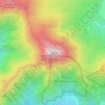
Name: Cerro Manquehue topographic map, elevation, terrain.
Average elevation: 1,183 m
Minimum elevation: 825 m
Maximum elevation: 1,626 m
Other topographic maps
Click on a map to view its topography, its elevation and its terrain.
Parque Bicentenario
Chile > Región Metropolitana de Santiago > Provincia de Santiago > Vitacura
Average elevation: 647 m
Parque Bicentenario
Chile > Región Metropolitana de Santiago > Provincia de Santiago > Vitacura
Average elevation: 647 m
Parque Bicentenario
Chile > Región Metropolitana de Santiago > Provincia de Santiago > Vitacura
Average elevation: 647 m
Parque Bicentenario
Chile > Región Metropolitana de Santiago > Provincia de Santiago > Vitacura
Average elevation: 647 m