Geolocate

Pulpite topographic map

Click on the map to display elevation.

About this map

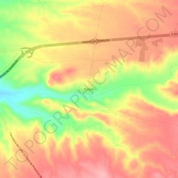
Name: Pulpite topographic map, elevation, terrain.

Location: Pulpite, Cúllar, Comarca de Baza, Granada, Andalucía, España (37.55604 -2.54853 37.59604 -2.50853)

Average elevation: 989 m

Minimum elevation: 905 m

Maximum elevation: 1,040 m

Gear up for your next adventure:

🔪Outdoor Multitool - Versatile tool for repairs and food prep in the wild
🍽️Titanium Camping Spork - Ultralight and indestructible eating utensil
🚲Heavy Duty Bike Lock - Secure your bike at the trailhead or during stops
Camping Groundsheet - Protect your tent from moisture and dirt
👟Trail Running Shoes - Agile footwear for fast-paced topographic exploration

As an Amazon Associate, this site earns from qualifying purchases at no extra cost to you.