Geolocate

Campdevànol topographic map

Click on the map to display elevation.

About this map

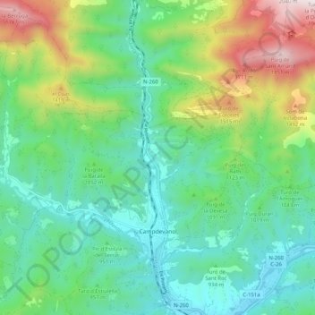
Name: Campdevànol topographic map, elevation, terrain.

Location: Campdevànol, Ripollès, Girona, Catalonia, 17530, Spain (42.20667 2.09384 42.27438 2.19512)

Average elevation: 1,026 m

Minimum elevation: 685 m

Maximum elevation: 1,888 m

Other topographic maps

Click on a map to view its topography, its elevation and its terrain.

Puigmal d'Err

Spain > Catalonia > Ripollès > Queralbs

Average elevation: 2,571 m

Fornells de la Muntanya

Spain > Catalonia > Ripollès

Average elevation: 1,566 m

Gear up for your next adventure:

🧰Emergency Multi-Tool - Compact multi-tool for outdoor survival
🔋Solar Power Bank - Keep your GPS and devices charged during long outdoor trips
🧥Waterproof Hiking Jacket - Protect yourself from rain and wind while hiking
🥾Light Hiking Boots - Lightweight and comfortable boots for day hikes
🪜Heavy Duty Carabiners - Multi-use clips for securing gear to your backpack

As an Amazon Associate, this site earns from qualifying purchases at no extra cost to you.