Geolocate

Banilad topographic map

Click on the map to display elevation.

About this map

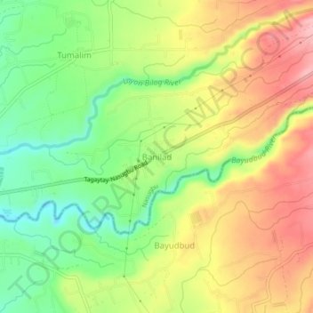
Name: Banilad topographic map, elevation, terrain.

Location: Banilad, Nasugbu, Batangas, Calabarzon, 4231, Philippines (14.04683 120.71400 14.08683 120.75400)

Average elevation: 99 m

Minimum elevation: 27 m

Maximum elevation: 175 m

Other topographic maps

Click on a map to view its topography, its elevation and its terrain.

Fortune Island

Philippines > Batangas > Nasugbu

Average elevation: 1 m

Fortune Island

Philippines > Batangas > Nasugbu

Average elevation: 1 m

Palico River

Philippines > Batangas > Nasugbu > Reparo

Average elevation: 44 m

Pico de Loro Beach

Philippines > Batangas > Nasugbu

Average elevation: 43 m

Batulao

Philippines > Batangas > Nasugbu

Average elevation: 531 m

Talamitam

Philippines > Batangas > Nasugbu > Kayrilaw

Average elevation: 328 m

Gear up for your next adventure:

🧥Waterproof Jacket - Lightweight rain jackets for hiking and outdoor activities
💡LED Headlamp - Hands-free illumination for night hiking and camping
🧴First Aid Kit - Essential first aid supplies for outdoor emergencies
🧥Softshell Jacket - Windproof and breathable jacket for hiking
🕯️Camping Lantern - Illuminates your entire campsite with high-efficiency LEDs

As an Amazon Associate, this site earns from qualifying purchases at no extra cost to you.