Geolocate

Dared topographic map

Click on the map to display elevation.

About this map

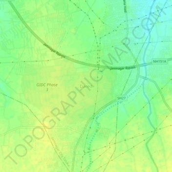
Name: Dared topographic map, elevation, terrain.

Location: Dared, Jamnagar City Taluka, Jamnagar, Gujarat, 361004, India (22.39573 70.03605 22.43573 70.07605)

Average elevation: 27 m

Minimum elevation: 16 m

Maximum elevation: 33 m

Other topographic maps

Click on a map to view its topography, its elevation and its terrain.

Jamnagar

India > Gujarat > Jamnagar City Taluka

Average elevation: 19 m

Jamnagar

India > Gujarat > Jamnagar City Taluka

Average elevation: 19 m

Jamnagar

India > Gujarat > Jamnagar City Taluka

Average elevation: 19 m

Gear up for your next adventure:

🛶Waterproof Dry Bags - Keep electronics and clothes dry during river crossings
🧢Hiking Sun Hat - Wide-brimmed protection for exposed mountain ridges
💧Filtered Water Bottle - Safe drinking water on the go
🧥Softshell Jacket - Windproof and breathable jacket for hiking
🛶Canoe Life Vest - Safety vest for water sports

As an Amazon Associate, this site earns from qualifying purchases at no extra cost to you.