Geolocate

Heverlee topographic map

Click on the map to display elevation.

About this map

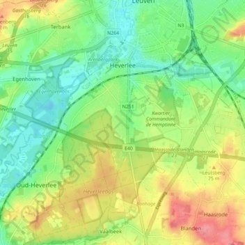
Name: Heverlee topographic map, elevation, terrain.

Location: Heverlee, Leuven, Flemish Brabant, Flanders, 3001, Belgium (50.82421 4.64030 50.88137 4.75404)

Average elevation: 51 m

Minimum elevation: 16 m

Maximum elevation: 103 m

Other topographic maps

Click on a map to view its topography, its elevation and its terrain.

Beneden-Kessel

Belgium > Flemish Brabant > Leuven > Leuven > Kessel-Lo

Average elevation: 34 m

Leuven

Belgium > Flemish Brabant > Leuven > Leuven

Average elevation: 50 m

Gear up for your next adventure:

🧥Fleece Jacket - Warm and lightweight jacket for layering
🌬️Windproof Camp Stove - Efficient cooking even on exposed mountain peaks
💡Compact LED Flashlight - Powerful and portable flashlight for outdoor use
🧰Emergency Multi-Tool - Compact multi-tool for outdoor survival
Lightweight Backpacking Tent - Compact tent for efficient hiking trips

As an Amazon Associate, this site earns from qualifying purchases at no extra cost to you.