
Make a donation
Gear up for your next adventure:
As an Amazon Associate, this site earns from qualifying purchases at no extra cost to you.
Ottaway Islet topographic map
Click on the map to display elevation.
Make a donation
Gear up for your next adventure:
As an Amazon Associate, this site earns from qualifying purchases at no extra cost to you.
About this map
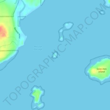
Name: Ottaway Islet topographic map, elevation, terrain.
Location: Ottaway Islet, Colombie-Britannique, Canada (48.97572 -125.38145 48.97683 -125.37989)
Average elevation: 3 m
Minimum elevation: -1 m
Maximum elevation: 50 m
Make a donation
Gear up for your next adventure:
As an Amazon Associate, this site earns from qualifying purchases at no extra cost to you.
Other topographic maps
Click on a map to view its topography, its elevation and its terrain.
Whistler Village
Canada > Colombie-Britannique > Squamish-Lillooet Regional District > Whistler Resort Municipality
Average elevation: 775 m
Mount Heimdal
Canada > Colombie-Britannique > Regional District of Central Kootenay > Area H (The Slocan Valley)
Average elevation: 2,062 m
Mount Harington
Canada > Colombie-Britannique > Central Coast Regional District > Area A (Ocean Falls/Outer Coast)
Average elevation: 421 m
Woodlot 0007
Canada > Colombie-Britannique > District régional du Grand Vancouver > Maple Ridge
Average elevation: 322 m
Make a donation
Gear up for your next adventure:
As an Amazon Associate, this site earns from qualifying purchases at no extra cost to you.
Cypress Lake
Canada > Colombie-Britannique > District régional du Grand Vancouver > Coquitlam
Average elevation: 738 m
Old Hogem
Canada > Colombie-Britannique > district régionel de Bulkley-Néchako > Area C (Stuart Lake/Omineca Valley)
Average elevation: 824 m
Mount Robson
Canada > Colombie-Britannique > District régional de Fraser-Fort George > Area H (Robson Valley/Canoe)
Average elevation: 3,037 m
Montagnes Rocheuses
Canada > Colombie-Britannique > Peace River Regional District > Area B (Finlay Valley/Beatton Valley)
Average elevation: 1,498 m
Make a donation
Gear up for your next adventure:
As an Amazon Associate, this site earns from qualifying purchases at no extra cost to you.
Bulkley-Nechako
Canada > Colombie-Britannique > district régionel de Bulkley-Néchako
Average elevation: 960 m
Grouse Mountain
Canada > Colombie-Britannique > District régional du Grand Vancouver
Le mont Grouse (anglais : Grouse Mountain) est une montagne des montagnes North Shore, au sein des chaînons du Pacifique, et dans le district de North Vancouver en Colombie-Britannique, au Canada. Elle culmine à 1 231 mètres d'altitude et possède une station de ski, Grouse Mountain Resort.
Average elevation: 968 m
Thunder Cove
Canada > Colombie-Britannique > Capital Regional District > Juan de Fuca Electoral Area
Average elevation: 2 m
Make a donation
Gear up for your next adventure:
As an Amazon Associate, this site earns from qualifying purchases at no extra cost to you.
Stave River
Canada > Colombie-Britannique > District régional de Fraser Valley
Average elevation: 91 m
Kootenay Columbia
Canada > Colombie-Britannique > Regional District of Kootenay Boundary > Area B (Lower Columbia/Old Glory)
Average elevation: 1,013 m
Lillooet River
Canada > Colombie-Britannique > Squamish-Lillooet Regional District > Area C (Pemberton Valley/Mount Currie/D'Arcy)
Average elevation: 342 m
Strathcona Park
Canada > Colombie-Britannique > District régional de Fraser Valley > Chilliwack > Minto Landing
Average elevation: 13 m
Make a donation
Gear up for your next adventure:
As an Amazon Associate, this site earns from qualifying purchases at no extra cost to you.
Moose Valley Provincial Park
Canada > Colombie-Britannique > Cariboo Regional District > Area G (Lac La Hache/108 Mile Ranch)
Average elevation: 1,176 m
Lac La Hache
Canada > Colombie-Britannique > Cariboo Regional District > Area G (Lac La Hache/108 Mile Ranch)
Average elevation: 847 m
Mastodon Mountain
Canada > Colombie-Britannique > Regional District of Fraser-Fort George > Area H (Robson Valley/Canoe)
Average elevation: 2,461 m
Cascade Mountains
Canada > Colombie-Britannique > Area I (Blue Sky Country)
Average elevation: 1,485 m
Make a donation
Gear up for your next adventure:
As an Amazon Associate, this site earns from qualifying purchases at no extra cost to you.
Roddick Creek
Canada > Colombie-Britannique > Area B (South Fraser Canyon/Sunshine Valley)
Average elevation: 922 m
Trout Lake
Canada > Colombie-Britannique > Columbia-Shuswap Regional District > Area B (Shelter Bay/Mica Creek) > Trout Lake
Average elevation: 823 m
Montagnes Rocheuses
Canada > Colombie-Britannique > Columbia-Shuswap Regional District > Area A (Kicking Horse/Kinbasket Lake)
Average elevation: 1,508 m
Make a donation
Gear up for your next adventure:
As an Amazon Associate, this site earns from qualifying purchases at no extra cost to you.
Blubber Bay
Canada > Colombie-Britannique > qathet Regional District > Area D (Texada Island) > Blubber Bay
Average elevation: 22 m
Mount St. Anne
Canada > Colombie-Britannique > Thompson-Nicola Regional District > Area B (Thompson Headwaters)
Average elevation: 1,901 m
Harrison Mills
Canada > Colombie-Britannique > Area C (Sasquatch Country) > Harrison Mills
Average elevation: 95 m
Fernie
Canada > Colombie-Britannique > Regional District of East Kootenay > Fernie
Average elevation: 1,551 m
Make a donation
Gear up for your next adventure:
As an Amazon Associate, this site earns from qualifying purchases at no extra cost to you.
Cultus Lake
Canada > Colombie-Britannique > Fraser Valley Regional District > Area H (Cultus Lake/Columbia Valley) > Cultus Lake
Average elevation: 189 m
Lake Country
Canada > Colombie-Britannique > Regional District of Central Okanagan > Lake Country > Lake Country
Average elevation: 528 m
Basque
Canada > Colombie-Britannique > Thompson-Nicola Regional District > Area I (Blue Sky Country)
Average elevation: 427 m
Galland Road Park
Canada > Colombie-Britannique > Cowichan Valley Regional District > Area B (Shawnigan Lake)
Average elevation: 166 m
Make a donation
Gear up for your next adventure:
As an Amazon Associate, this site earns from qualifying purchases at no extra cost to you.
Barkerville
Canada > Colombie-Britannique > Cariboo Regional District > Area C (Bowron Lake/Barlow Creek/Barkerville)
Average elevation: 1,435 m
Dezaiko Range
Canada > Colombie-Britannique > District régional de Fraser-Fort George > Area F (Willow River/Upper Fraser)
Average elevation: 1,722 m
Kakawis
Canada > Colombie-Britannique > Alberni-Clayoquot Regional District > Area C (Long Beach)
Average elevation: 50 m
Albreda
Canada > Colombie-Britannique > District régional de Fraser-Fort George > Area H (Robson Valley/Canoe)
Average elevation: 1,036 m
Make a donation
Gear up for your next adventure:
As an Amazon Associate, this site earns from qualifying purchases at no extra cost to you.
Ganges
Canada > Colombie-Britannique > Capital Regional District > Salt Spring Island Electoral Area
Average elevation: 113 m
Point frontalier non-marqué 97
Canada > Colombie-Britannique > région Stikine
Average elevation: 2,078 m
Detwiller Point
Canada > Colombie-Britannique > Cowichan Valley Regional District > Area G (Saltair / Gulf Islands)
Average elevation: 33 m
The Copilot
Canada > Colombie-Britannique > Squamish-Lillooet Regional District > Area D (Elaho/Garibaldi)
Average elevation: 1,466 m
Make a donation
Gear up for your next adventure:
As an Amazon Associate, this site earns from qualifying purchases at no extra cost to you.
Mount Robson
Canada > Colombie-Britannique > District régional de Fraser-Fort George > Area H (Robson Valley/Canoe)
Average elevation: 3,037 m
Eliguk Lake
Canada > Colombie-Britannique > Cariboo Regional District > Area J (West Chilcotin)
Average elevation: 1,135 m
Sun Peaks Mountain Resort Municipality
Canada > Colombie-Britannique > Thompson-Nicola Regional District
Average elevation: 1,589 m