
Lang topographic map
Click on the map to display elevation.
About this map
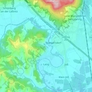
Name: Lang topographic map, elevation, terrain.
Location: Lang, Bezirk Leibnitz, Styria, 8403, Austria (46.82391 15.46699 46.87132 15.53274)
Average elevation: 319 m
Minimum elevation: 272 m
Maximum elevation: 549 m
Other topographic maps
Click on a map to view its topography, its elevation and its terrain.
Lamperstätten
Austria > Styria > Bezirk Leibnitz > Sankt Nikolai im Sausal > Mollitsch
Average elevation: 322 m