Geolocate

Cabrera topographic map

Click on the map to display elevation.

About this map

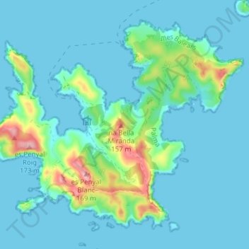
Name: Cabrera topographic map, elevation, terrain.

Location: Cabrera, Palma, Balearic Islands, Spain (39.12503 2.91417 39.16566 2.97649)

Average elevation: 25 m

Minimum elevation: -1 m

Maximum elevation: 167 m

Gear up for your next adventure:

❄️Traction Ice Cleats - Slip-on spikes for icy trails and winter hiking
🥾Trekking Boots - Durable boots for long-distance trekking
🕯️Camping Lantern - Illuminates your entire campsite with high-efficiency LEDs
🧼Travel Hand Sanitizer - Keep hands clean when water is scarce
🧢Hiking Hat - Sun-protective and breathable hats for long treks

As an Amazon Associate, this site earns from qualifying purchases at no extra cost to you.