Geolocate

Anula topographic map

Click on the map to display elevation.

About this map

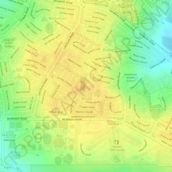
Name: Anula topographic map, elevation, terrain.

Location: Anula, City of Darwin, Northern Territory, 0812, Australia (-12.39595 130.88320 -12.38460 130.89778)

Average elevation: 29 m

Minimum elevation: 8 m

Maximum elevation: 39 m

Other topographic maps

Click on a map to view its topography, its elevation and its terrain.

Darwin

Australia > City of Darwin

Average elevation: 8 m

Darwin

Australia > City of Darwin

Average elevation: 8 m

Darwin

Australia > City of Darwin

Average elevation: 8 m

Darwin

Australia > City of Darwin

Average elevation: 8 m

Darwin

Australia > City of Darwin

Average elevation: 8 m

Darwin

Australia > City of Darwin

Average elevation: 8 m

Gear up for your next adventure:

🥤Collapsible Travel Cup - Saves space and weight in your mess kit
🥾Waterproof Trail Shoes - Shoes designed to handle wet terrain
🧥Ultralight Puffy Jacket - Maximum warmth that packs down to the size of an orange
🧣Evaporative Cooling Towel - Beat the heat during intense summer climbs
🧥Packable Rain Jacket - Breathable waterproof layer for unpredictable weather

As an Amazon Associate, this site earns from qualifying purchases at no extra cost to you.