
Tamarin topographic map
Interactive map
Click on the map to display elevation.
About this map
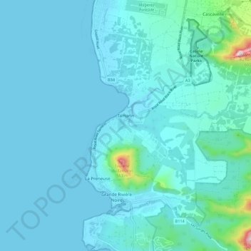
Name: Tamarin topographic map, elevation, terrain.
Location: Tamarin, Rivière Noire, Maurice (-20.36336 57.36262 -20.30302 57.47027)
Average elevation: 53 m
Minimum elevation: 0 m
Maximum elevation: 618 m
Other topographic maps
Click on a map to view its topography, its elevation and its terrain.
Pointe aux Sables
Maurice > Rivière Noire > Pointe aux Sables
Pointe aux Sables, Rivière Noire, 230, Maurice
Average elevation: 22 m
Tamarin
Maurice > Rivière Noire > Tamarin
Tamarin, Rivière Noire, 90608, Maurice
Average elevation: 48 m