Geolocate

San Jose Province topographic map

Interactive map

Click on the map to display elevation.

About this map

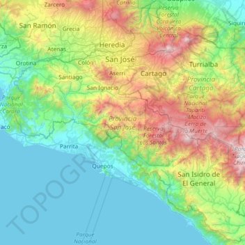
Name: San Jose Province topographic map, elevation, terrain.

Location: San Jose Province, Costa Rica (9.07489 -84.59268 10.18785 -83.42938)

Average elevation: 804 m

Minimum elevation: -1 m

Maximum elevation: 3,758 m

Other topographic maps

Click on a map to view its topography, its elevation and its terrain.

Cantón de Parrita

Costa Rica

Parrita has an area of 478.79 km2 and a mean elevation of 4 metres.

Average elevation: 219 m

Frailes

Costa Rica > Cantón de Desamparados

Average elevation: 1,492 m

Cantón de León Cortés Castro

Costa Rica

León Cortés Castro has an area of 120.8 km² and a mean elevation of 1,620 metres.

Average elevation: 1,575 m

Ojochal

Costa Rica > Cantón de Carrillo > Belén

Average elevation: 71 m

San José

Costa Rica > Cantón San José > Hospital

Average elevation: 1,368 m

Provincia Guanacaste

Costa Rica

Guanacaste's climate and culture are unique among Costa Rican provinces. The province experiences little rain and consistent heat from November to April, resulting in ubiquitous tropical dry forests as a natural adaption to the dry season conditions. Tourists seek out this dry heat during the North American…

Average elevation: 137 m

Cocos Island

Costa Rica > Cantón Puntarenas

Average elevation: 77 m

Alajuela Province

Costa Rica

Average elevation: 420 m

Cantón Buenos Aires

Costa Rica

Buenos Aires has an area of 2,384.22 km2 and a mean elevation of 386 metres.

Average elevation: 1,003 m

Cantón Liberia

Costa Rica

Liberia has an area of 1,436.47 km2 and a mean elevation of 193 metres. Prominent geologic features of Liberia include Cerro Cacao (Cacao Mountain) and Rincón de la Vieja. The latter is the center of the Rincón de la Vieja Volcano National Park. The canton also includes the most visited portion of Santa Rosa…

Average elevation: 237 m

San Rafael

Costa Rica > Cantón Escazú

Average elevation: 1,056 m

San Vicente

Costa Rica > Cantón Moravia

San Vicente has an area of 5.39 km² and an elevation of 1,231 metres.

Average elevation: 1,230 m

Puntarenas Province

Costa Rica

Average elevation: 111 m

Cahuita

Costa Rica > Cantón Talamanca

Average elevation: 99 m

Catarata

Costa Rica > Cantón Talamanca > Cahuita

Average elevation: 127 m

Uruca

Costa Rica > Cantón San José

Uruca has an area of 8.44 km² and an elevation of 1,112 metres.

Average elevation: 1,112 m

Nosara

Costa Rica > Cantón Nicoya

Average elevation: 118 m

Río Jiménez

Costa Rica > Cantón Pococí > Guácimo > Jiménez

Average elevation: 382 m

Yerba

Costa Rica > Cantón Golfito > Pavón

Average elevation: 179 m

Cantón Grecia

Costa Rica > Alajuela Province

Average elevation: 1,253 m

Tamarindo

Costa Rica > Cantón Santa Cruz

Tamarindo has an area of 125.86 km² and an elevation of 27 metres.

Average elevation: 27 m

Córdoba

Costa Rica > Cantón San José > Zapote

Average elevation: 1,165 m

Garita

Costa Rica > Alajuela Province > Cantón Alajuela > Garita

Average elevation: 672 m

Puerto Viejo

Costa Rica > Cantón Sarapiquí

Average elevation: 45 m

Cantón de Paraíso

Costa Rica

Paraíso has an area of 476.99 km2 (184.17 sq mi) and a mean elevation of 1,171 m (3,842 ft).

Average elevation: 1,821 m

Monteverde

Costa Rica > Cantón de Monteverde

Average elevation: 1,209 m

Santiago

Costa Rica > Cantón Paraíso

The city lies in the center of the Santiago Basin, a large bowl-shaped valley consisting of broad and fertile lands surrounded by mountains. The city has a varying elevation, gradually increasing from 400 m (1,312 ft) in the western areas to more than 700 m (2,297 ft) in the eastern areas. Santiago's…

Average elevation: 1,275 m

Sámara

Costa Rica > Cantón de Nicoya

Average elevation: 160 m

Limón Province

Costa Rica

The majority of Limón's land lies at sea level, though its western border sees an increase in altitude due largely to the Cordillera de Talamanca. The province's indigenous populations largely reside in reserves that occupy much of the cantón of Talamanca.

Average elevation: 435 m

Cartago Province

Costa Rica

Average elevation: 1,374 m

Nicoya

Costa Rica > Provincia Guanacaste > Nicoya

Average elevation: 280 m

Cantón San José

Costa Rica > Provincia San José

Average elevation: 1,197 m

Cantón Pérez Zeledón

Costa Rica

Pérez Zeledón has an area of 1,905.51 km2[7] and a mean elevation of 690 metres.[2]

Average elevation: 1,203 m

Pavones

Costa Rica > Provincia Cartago > Pavones

Average elevation: 758 m

Irazú Volcano

Costa Rica > Cantón Oreamuno > Santa Rosa

The Irazú volcano is a complex volcanic shield. It is the highest active volcano in Costa Rica, and has an area of 500 km2 (190 sq mi). It has an irregular subconic shape, and temperatures at its summit vary between 3 and 17 °C (37 and 63 °F), with a record low of −3 °C(26.6 °F) and a record high of…

Average elevation: 3,114 m