
Make a donation
Gear up for your next adventure:
As an Amazon Associate, this site earns from qualifying purchases at no extra cost to you.
Le Rimbau topographic map
Click on the map to display elevation.
Make a donation
Gear up for your next adventure:
As an Amazon Associate, this site earns from qualifying purchases at no extra cost to you.
About this map
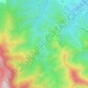
Name: Le Rimbau topographic map, elevation, terrain.
Average elevation: 274 m
Minimum elevation: 7 m
Maximum elevation: 773 m
Make a donation
Gear up for your next adventure:
As an Amazon Associate, this site earns from qualifying purchases at no extra cost to you.
Other topographic maps
Click on a map to view its topography, its elevation and its terrain.
Fort Saint-Elme
France > Occitanie > Pyrénées-Orientales > Collioure > Les Batteries
Le fort Saint-Elme est situé, à 170 mètres d'altitude, près de la limite est-sud-est de la commune de Collioure, sur une ligne de crête surplombant Collioure (par le sud-est) et Port-Vendres (par l'ouest), et dans le prolongement nord-est du fort Dugommier (223 mètres d'altitude). On peut y accéder par…
Average elevation: 64 m