
Make a donation
Gear up for your next adventure:
As an Amazon Associate, this site earns from qualifying purchases at no extra cost to you.
Bad Sassendorf topographic map
Click on the map to display elevation.
Make a donation
Gear up for your next adventure:
As an Amazon Associate, this site earns from qualifying purchases at no extra cost to you.
About this map
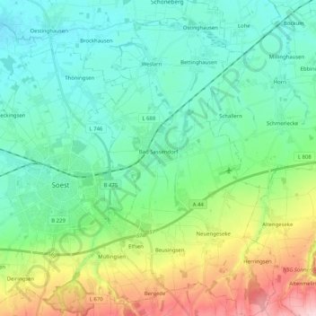
Name: Bad Sassendorf topographic map, elevation, terrain.
Average elevation: 125 m
Minimum elevation: 68 m
Maximum elevation: 287 m
Make a donation
Gear up for your next adventure:
As an Amazon Associate, this site earns from qualifying purchases at no extra cost to you.
Other topographic maps
Click on a map to view its topography, its elevation and its terrain.
Wiebusch
Deutschland > Nordrhein-Westfalen > Kreis Soest > Warstein > Belecke
Average elevation: 293 m
Echthausen
Deutschland > Nordrhein-Westfalen > Kreis Soest > Wickede (Ruhr) > Echthausen
Average elevation: 182 m
Make a donation
Gear up for your next adventure:
As an Amazon Associate, this site earns from qualifying purchases at no extra cost to you.
Bad Westernkotten
Deutschland > Nordrhein-Westfalen > Kreis Soest > Erwitte
Wirtschaftlich spielte im 19. Jahrhundert die Salzindustrie weiterhin die wichtigste Rolle und erreichte mit einer jährlichen Produktion von etwa 35.000 Zentnern um 1850 ihren Höhepunkt.
Average elevation: 94 m