
Mashhad topographic map
Interactive map
Click on the map to display elevation.
About this map
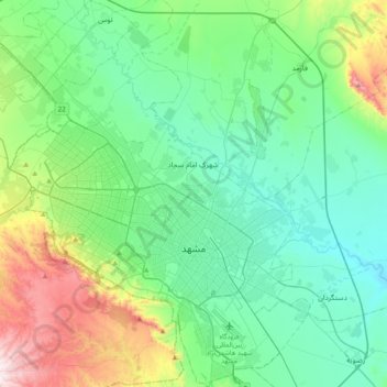
Name: Mashhad topographic map, elevation, terrain.
Average elevation: 1,072 m
Minimum elevation: 890 m
Maximum elevation: 1,684 m
Other topographic maps
Click on a map to view its topography, its elevation and its terrain.
شهید رضوی
Iran > Khorassan Ravazi > شهرستان مشهد > Mashhad
شهید رضوی, ناحیه ۱ منطقه ۱۱, Région 11, Mashhad, بخش مرکزی شهرستان مشهد, شهرستان مشهد, Khorassan Ravazi, Iran
Average elevation: 1,048 m