
Make a donation
Gear up for your next adventure:
As an Amazon Associate, this site earns from qualifying purchases at no extra cost to you.
Heroldsberg topographic map
Click on the map to display elevation.
Make a donation
Gear up for your next adventure:
As an Amazon Associate, this site earns from qualifying purchases at no extra cost to you.
Heroldsberg
Der Ort, der beachtliche Höhenunterschiede aufweist, liegt im Sebalder Reichswald. Die Gründlach, ein Nebenfluss der Regnitz, führt durch den Ort, an dessen Südende die Simmelberger Gründlach zufließt.
Make a donation
Gear up for your next adventure:
As an Amazon Associate, this site earns from qualifying purchases at no extra cost to you.
About this map
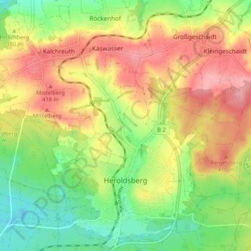
Name: Heroldsberg topographic map, elevation, terrain.
Average elevation: 376 m
Minimum elevation: 322 m
Maximum elevation: 432 m
Make a donation
Gear up for your next adventure:
As an Amazon Associate, this site earns from qualifying purchases at no extra cost to you.
Other topographic maps
Click on a map to view its topography, its elevation and its terrain.
Adlitz
Deutschland > Bayern > Landkreis Erlangen-Höchstadt
Das Dorf liegt am nördlichen Hang des Höhenzuges von Rathsberg nach Marloffstein. Unmittelbar ist der Ort von Acker- und Grünland umgeben. Etwas weiter westlich und östlich befinden sich Waldgebiete, das östliche wird Bergholz genannt. Durch diese Waldgebiete fließen zwei namenlose Bäche, die in…
Average elevation: 332 m
Höchstadt an der Aisch
Deutschland > Bayern > Landkreis Erlangen-Höchstadt > Höchstadt a.d.Aisch > Höchstadt an der Aisch
Average elevation: 296 m
Make a donation
Gear up for your next adventure:
As an Amazon Associate, this site earns from qualifying purchases at no extra cost to you.
Make a donation
Gear up for your next adventure:
As an Amazon Associate, this site earns from qualifying purchases at no extra cost to you.
Lappach
Deutschland > Bayern > Landkreis Erlangen-Höchstadt > Höchstadt a.d.Aisch
Average elevation: 292 m
Make a donation
Gear up for your next adventure:
As an Amazon Associate, this site earns from qualifying purchases at no extra cost to you.
Zweifelsheim
Deutschland > Bayern > Landkreis Erlangen-Höchstadt > Herzogenaurach
Average elevation: 362 m
Zentbechhofen
Deutschland > Bayern > Landkreis Erlangen-Höchstadt > Höchstadt an der Aisch
Average elevation: 303 m
Make a donation
Gear up for your next adventure:
As an Amazon Associate, this site earns from qualifying purchases at no extra cost to you.
Rathsberg
Deutschland > Bayern > Landkreis Erlangen-Höchstadt
Der Ort und das gleichnamige Schloss Rathsberg liegen auf dem höchsten, westlichen Punkt des gleichnamigen Höhenzugs Rathsberg nordöstlich von Erlangen.
Average elevation: 307 m
Beutelsdorf
Deutschland > Bayern > Landkreis Erlangen-Höchstadt > Herzogenaurach
Average elevation: 326 m
Eckental
Deutschland > Bayern > Landkreis Erlangen-Höchstadt > Eckental > Eckental
Average elevation: 361 m
Make a donation
Gear up for your next adventure:
As an Amazon Associate, this site earns from qualifying purchases at no extra cost to you.
Hauptendorf
Deutschland > Bayern > Landkreis Erlangen-Höchstadt > Herzogenaurach
Average elevation: 320 m
Oberschöllenbach
Deutschland > Bayern > Landkreis Erlangen-Höchstadt > Eckental
Average elevation: 349 m
Make a donation
Gear up for your next adventure:
As an Amazon Associate, this site earns from qualifying purchases at no extra cost to you.
Kleinseebach
Deutschland > Bayern > Landkreis Erlangen-Höchstadt > Kleinseebach
Average elevation: 284 m
Jungenhofen
Deutschland > Bayern > Landkreis Erlangen-Höchstadt > Höchstadt a.d.Aisch
Average elevation: 303 m
Make a donation
Gear up for your next adventure:
As an Amazon Associate, this site earns from qualifying purchases at no extra cost to you.
Burgstall
Deutschland > Bayern > Landkreis Erlangen-Höchstadt > Herzogenaurach
Average elevation: 335 m
Make a donation
Gear up for your next adventure:
As an Amazon Associate, this site earns from qualifying purchases at no extra cost to you.