Geolocate

Zgierz topographic map

Click on the map to display elevation.

About this map

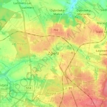
Name: Zgierz topographic map, elevation, terrain.

Location: Zgierz, Zgierz County, Łódzkie Voivodship, Poland (51.82149 19.33139 51.88972 19.45674)

Average elevation: 193 m

Minimum elevation: 157 m

Maximum elevation: 229 m

Gear up for your next adventure:

🕯️Camping Lantern - Illuminates your entire campsite with high-efficiency LEDs
🧥Insulated Jacket - Keep warm in cold outdoor conditions
🔋Emergency Crank Radio - Weather alerts and power without needing batteries
🧢Sun Hat - Wide-brim hat for sun protection
🛶Waterproof Dry Bags - Keep electronics and clothes dry during river crossings

As an Amazon Associate, this site earns from qualifying purchases at no extra cost to you.