Geolocate

Yarm topographic map

Interactive map

Click on the map to display elevation.

About this map

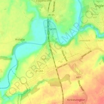
Name: Yarm topographic map, elevation, terrain.

Location: Yarm, Stockton-on-Tees, Tees Valley, England, United Kingdom (54.48837 -1.38100 54.51239 -1.31338)

Average elevation: 29 m

Minimum elevation: 1 m

Maximum elevation: 55 m

Other topographic maps

Click on a map to view its topography, its elevation and its terrain.

Billingham

United Kingdom > England > Stockton-on-Tees

Billingham, Stockton-on-Tees, Tees Valley, England, United Kingdom

Average elevation: 21 m

Stockton-on-Tees

United Kingdom > England > Stockton-on-Tees

Stockton-on-Tees, Tees Valley, England, United Kingdom

Average elevation: 19 m

Stockton-on-Tees

United Kingdom > England > Stockton-on-Tees > Stockton-on-Tees

Stockton-on-Tees, North East England, England, United Kingdom

Average elevation: 17 m