Geolocate

High Springs topographic map

Click on the map to display elevation.

About this map

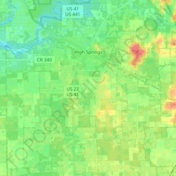
Name: High Springs topographic map, elevation, terrain.

Location: High Springs, Alachua County, Florida, 32655, United States (29.74830 -82.64500 29.85839 -82.51422)

Average elevation: 25 m

Minimum elevation: 8 m

Maximum elevation: 55 m

Gear up for your next adventure:

🧴Sunscreen SPF - Broad-spectrum sunscreen for outdoor activities
🛶Waterproof Dry Bags - Keep electronics and clothes dry during river crossings
💡Compact LED Flashlight - Powerful and portable flashlight for outdoor use
🔋Lithium AA Batteries - Long-lasting power that performs in extreme cold
💧Reusable Water Bottle - Durable water bottles for hydration on trails

As an Amazon Associate, this site earns from qualifying purchases at no extra cost to you.