
Make a donation
Gear up for your next adventure:
As an Amazon Associate, this site earns from qualifying purchases at no extra cost to you.
Dünnwald topographic map
Click on the map to display elevation.
Make a donation
Gear up for your next adventure:
As an Amazon Associate, this site earns from qualifying purchases at no extra cost to you.
Dünnwald
Dünnwald grenzt im Osten an Bergisch Gladbach, im Süden an Dellbrück und Höhenhaus, im Westen an Flittard und im Norden an Leverkusen.
Make a donation
Gear up for your next adventure:
As an Amazon Associate, this site earns from qualifying purchases at no extra cost to you.
About this map
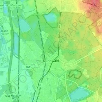
Name: Dünnwald topographic map, elevation, terrain.
Location: Dünnwald, Mülheim, Köln, Nordrhein-Westfalen, Deutschland (50.98645 7.01200 51.02112 7.07606)
Average elevation: 55 m
Minimum elevation: 32 m
Maximum elevation: 95 m
Make a donation
Gear up for your next adventure:
As an Amazon Associate, this site earns from qualifying purchases at no extra cost to you.
Other topographic maps
Click on a map to view its topography, its elevation and its terrain.
Make a donation
Gear up for your next adventure:
As an Amazon Associate, this site earns from qualifying purchases at no extra cost to you.