
Make a donation
Gear up for your next adventure:
As an Amazon Associate, this site earns from qualifying purchases at no extra cost to you.
Barnstable topographic map
Click on the map to display elevation.
Make a donation
Gear up for your next adventure:
As an Amazon Associate, this site earns from qualifying purchases at no extra cost to you.
About this map
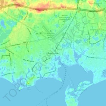
Name: Barnstable topographic map, elevation, terrain.
Location: Barnstable, Barnstable County, Massachusetts, United States (41.61398 -70.32196 41.69398 -70.24196)
Average elevation: 10 m
Minimum elevation: -4 m
Maximum elevation: 43 m
Make a donation
Gear up for your next adventure:
As an Amazon Associate, this site earns from qualifying purchases at no extra cost to you.
Other topographic maps
Click on a map to view its topography, its elevation and its terrain.
Cliffside Estates
United States > Massachusetts > Barnstable County > Bourne > Sagamore Highlands
Average elevation: 18 m
Make a donation
Gear up for your next adventure:
As an Amazon Associate, this site earns from qualifying purchases at no extra cost to you.
Santuit Pond
United States > Massachusetts > Barnstable County > Mashpee > Mashpee Neck > Pine Tree Corner
Average elevation: 15 m
Sandwich Fish Hatchery
United States > Massachusetts > Barnstable County > Sandwich
Average elevation: 23 m
Make a donation
Gear up for your next adventure:
As an Amazon Associate, this site earns from qualifying purchases at no extra cost to you.
Peters Pond
United States > Massachusetts > Barnstable County > Sandwich > Forestdale
Average elevation: 40 m
Bog Pond Cr, Waquoit
United States > Massachusetts > Barnstable County > Falmouth
Average elevation: 7 m