Geolocate

Aldersyde topographic map

Click on the map to display elevation.

About this map

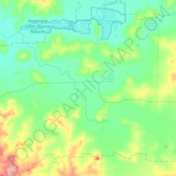
Name: Aldersyde topographic map, elevation, terrain.

Location: Aldersyde, Shire Of Brookton, Western Australia, Australia (-32.41659 117.13945 -32.21813 117.41280)

Average elevation: 245 m

Minimum elevation: 205 m

Maximum elevation: 372 m

Other topographic maps

Click on a map to view its topography, its elevation and its terrain.

Watervalley Park

Australia > Western Australia

Average elevation: 29 m

Moorehead

Australia > Western Australia

Average elevation: 197 m

Swan River

Australia > Western Australia

Average elevation: 113 m

Augusta

Australia > Western Australia > Augusta

Average elevation: 31 m

Honeymoon Bay

Australia > Western Australia

Average elevation: 7 m

Cooke Creek

Australia > Western Australia > Onslow

Average elevation: 2 m

Kings Park

Australia > Western Australia > Perth

Average elevation: 31 m

Minah Point Yard

Australia > Western Australia

Average elevation: 220 m

Ardath

Australia > Western Australia > Ardath

Average elevation: 285 m

Joondalup

Australia > Western Australia

Average elevation: 33 m

Gear up for your next adventure:

🌬️Windproof Camp Stove - Efficient cooking even on exposed mountain peaks
🧰Emergency Multi-Tool - Compact multi-tool for outdoor survival
🧢Hiking Hat - Sun-protective and breathable hats for long treks
🥾Trail Hiking Boots - Supportive boots for rough trails
🕶️Polarized Sunglasses - Reduces glare from snow and water at high elevations

As an Amazon Associate, this site earns from qualifying purchases at no extra cost to you.