
Champel topographic map
Interactive map
Click on the map to display elevation.
About this map
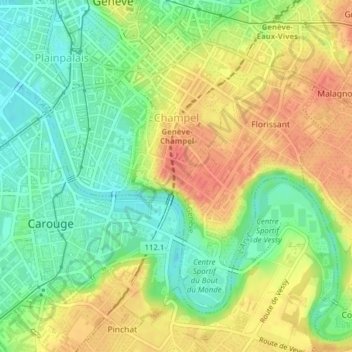
Name: Champel topographic map, elevation, terrain.
Location: Champel, Genève, 1206, Suisse (46.17777 6.14730 46.19881 6.17264)
Average elevation: 403 m
Minimum elevation: 374 m
Maximum elevation: 435 m
Other topographic maps
Click on a map to view its topography, its elevation and its terrain.
Petit-Saconnex et Servette
Petit-Saconnex et Servette, Genève, 1209, Suisse
Average elevation: 426 m
Parc Geisendorf
Parc Geisendorf, Grottes et Saint-Gervais, Genève, 1211, Suisse
Average elevation: 407 m