
Grad Gospić topographic map
Interactive map
Click on the map to display elevation.
About this map
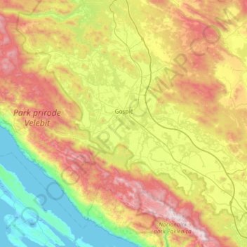
Name: Grad Gospić topographic map, elevation, terrain.
Location: Grad Gospić, Lika-Senj County, Croatia (44.33952 15.06300 44.70971 15.65121)
Average elevation: 668 m
Minimum elevation: -4 m
Maximum elevation: 1,751 m
Other topographic maps
Click on a map to view its topography, its elevation and its terrain.
Plitvice Lakes National Park
Croatia > Lika-Senj County > Plitvički Ljeskovac
The afforested mountain slopes serve as water reservoirs. They are also a refuge for many animal species. The large difference in altitude in a narrow space between the mountains in the south and the Korana river in the north also represents a significant criterion for biodiversity in this region. The overall…
Average elevation: 765 m