
Lafont topographic map
Interactive map
Click on the map to display elevation.
About this map
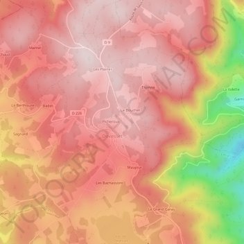
Name: Lafont topographic map, elevation, terrain.
Average elevation: 1,093 m
Minimum elevation: 792 m
Maximum elevation: 1,211 m
Other topographic maps
Click on a map to view its topography, its elevation and its terrain.
Le Grand Garay
France > Auvergne-Rhône-Alpes > Ardèche > Devesset
Le Grand Garay, Devesset, Tournon-sur-Rhône, Ardèche, Auvergne-Rhône-Alpes, France métropolitaine, 07320, France
Average elevation: 1,047 m
Lac de Devesset
France > Auvergne-Rhône-Alpes > Ardèche > Devesset > Meyfraiches
Lac de Devesset, Meyfraiches, Devesset, Tournon-sur-Rhône, Ardèche, Auvergne-Rhône-Alpes, France métropolitaine, 07320, France
Average elevation: 1,082 m