
Make a donation
Gear up for your next adventure:
As an Amazon Associate, this site earns from qualifying purchases at no extra cost to you.
Nelson Forks topographic map
Click on the map to display elevation.
Make a donation
Gear up for your next adventure:
As an Amazon Associate, this site earns from qualifying purchases at no extra cost to you.
About this map
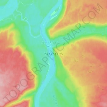
Name: Nelson Forks topographic map, elevation, terrain.
Average elevation: 297 m
Minimum elevation: 236 m
Maximum elevation: 376 m
Make a donation
Gear up for your next adventure:
As an Amazon Associate, this site earns from qualifying purchases at no extra cost to you.
Other topographic maps
Click on a map to view its topography, its elevation and its terrain.
Tetsa River
Canada > British Columbia > Northern Rockies Regional Municipality
Average elevation: 1,610 m
Muncho Lake
Canada > British Columbia > Northern Rockies Regional Municipality
The lake is part of the Muncho Lake Provincial Park and located at kilometre 681 (mile 423) of the Alaska Highway. The lake is about 12 km (7.5 mi) long and its width varies. It reaches a maximum depth of 110 m (360 ft). The surrounding peaks (the Terminal Range of the Muskwa Ranges to the west and the…
Average elevation: 1,322 m