
Thank you for supporting this site ❤️
Make a donation
Make a donation
Gear up for your next adventure:
As an Amazon Associate, this site earns from qualifying purchases at no extra cost to you.
Balkırı topographic map
Click on the map to display elevation.
Thank you for supporting this site ❤️
Make a donation
Make a donation
Gear up for your next adventure:
As an Amazon Associate, this site earns from qualifying purchases at no extra cost to you.
About this map
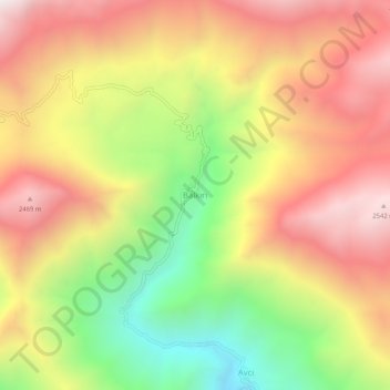
Name: Balkırı topographic map, elevation, terrain.
Location: Balkırı, Kemaliye, Erzincan, Oost-Anatolië, Turkije (39.23053 38.77358 39.27053 38.81358)
Average elevation: 2,000 m
Minimum elevation: 1,302 m
Maximum elevation: 2,600 m
Thank you for supporting this site ❤️
Make a donation
Make a donation
Gear up for your next adventure:
As an Amazon Associate, this site earns from qualifying purchases at no extra cost to you.