Geolocate

New Market topographic map

Click on the map to display elevation.

About this map

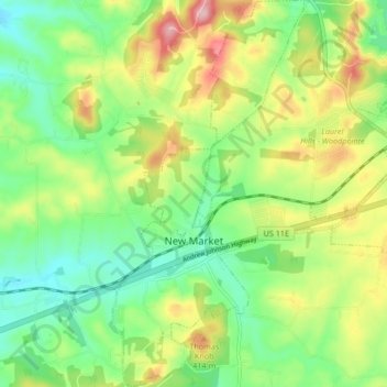
Name: New Market topographic map, elevation, terrain.

Location: New Market, Jefferson County, East Tennessee, Tennessee, 37820, United States (36.07850 -83.57022 36.14583 -83.51743)

Average elevation: 352 m

Minimum elevation: 284 m

Maximum elevation: 462 m

Other topographic maps

Click on a map to view its topography, its elevation and its terrain.

Cherokee Dam

United States > Tennessee > Jefferson County

Cherokee Dam is a gravity-type concrete spillway dam consisting of nine crest gates and eight sluice gates (the latter allowing reservoir control when water level is low). The combined capacity of the dam's four hydroelectric generators is 135,200 kilowatts. Cherokee Lake has a flood-storage capacity of…

Average elevation: 317 m

Woolardtown

United States > Tennessee > Jefferson County

Average elevation: 365 m

Swann

United States > Tennessee > Jefferson County

Average elevation: 309 m

Gear up for your next adventure:

🍽️Titanium Camping Spork - Ultralight and indestructible eating utensil
🛁Quick-Dry Microfiber Towel - Space-saving towel that dries rapidly on the move
💡Compact LED Flashlight - Powerful and portable flashlight for outdoor use
🚲MTB Frame Bag - Carry tools and maps directly on your bicycle frame
🧥Softshell Hiking Jacket - The perfect balance of wind protection and breathability

As an Amazon Associate, this site earns from qualifying purchases at no extra cost to you.