
Thank you for supporting this site ❤️
Make a donation
Make a donation
Gear up for your next adventure:
As an Amazon Associate, this site earns from qualifying purchases at no extra cost to you.
Lindström topographic map
Click on the map to display elevation.
Thank you for supporting this site ❤️
Make a donation
Make a donation
Gear up for your next adventure:
As an Amazon Associate, this site earns from qualifying purchases at no extra cost to you.
About this map
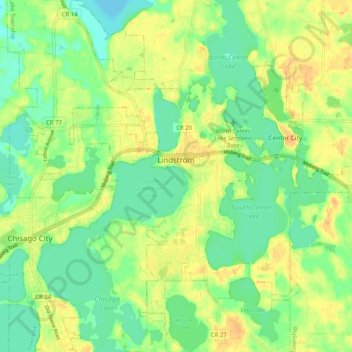
Name: Lindström topographic map, elevation, terrain.
Location: Lindström, Chisago County, Minnesota, 55045, United States (45.35054 -92.87827 45.42148 -92.81200)
Average elevation: 278 m
Minimum elevation: 263 m
Maximum elevation: 293 m
Thank you for supporting this site ❤️
Make a donation
Make a donation
Gear up for your next adventure:
As an Amazon Associate, this site earns from qualifying purchases at no extra cost to you.
Other topographic maps
Click on a map to view its topography, its elevation and its terrain.
Moody Lake
United States > Minnesota > Chisago County > Chisago Lake Township
Average elevation: 283 m