Geolocate

1900 topographic map

Click on the map to display elevation.

About this map

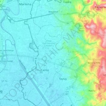
Name: 1900 topographic map, elevation, terrain.

Location: 1900, Cainta, Rizal, Calabarzon, Philippines (14.54785 121.09463 14.63657 121.14508)

Average elevation: 45 m

Minimum elevation: 0 m

Maximum elevation: 239 m

Other topographic maps

Click on a map to view its topography, its elevation and its terrain.

Sapang Bato

Philippines > Rizal > Cainta

Average elevation: 11 m

Cainta River

Philippines > Rizal > Cainta

Average elevation: 7 m

Hakbangan Creek

Philippines > Rizal > Cainta

Average elevation: 11 m

Sapang Bato

Philippines > Rizal > Cainta

Average elevation: 11 m

Gear up for your next adventure:

🧭Orienteering Kit - Tools for map reading and navigation in the wild
🚲Heavy Duty Bike Lock - Secure your bike at the trailhead or during stops
🧥Insulated Jacket - Keep warm in cold outdoor conditions
🧢Outdoor Cap - Protective cap for sun and rain during hikes
👟Leg Gaiters - Keep debris, mud, and snow out of your boots

As an Amazon Associate, this site earns from qualifying purchases at no extra cost to you.