Geolocate

Killeen topographic map

Click on the map to display elevation.

About this map

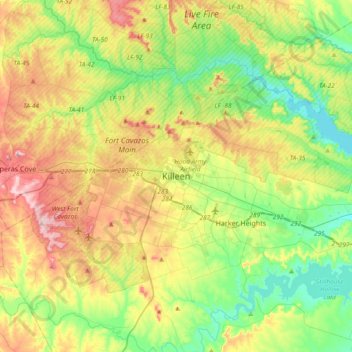
Name: Killeen topographic map, elevation, terrain.

Location: Killeen, Bell County, Texas, 76541, United States (30.95714 -97.88780 31.27714 -97.56780)

Average elevation: 257 m

Minimum elevation: 179 m

Maximum elevation: 380 m

Gear up for your next adventure:

🍽️Titanium Camping Spork - Ultralight and indestructible eating utensil
🥾Light Trekking Boots - Supportive boots for multi-day treks
Lightweight Camping Tent - Portable shelter optimized for Canadian backcountry camping
🗺️Topographic Maps - Detailed maps to explore trails, mountains, and wilderness areas
🛶Waterproof Dry Bags - Keep electronics and clothes dry during river crossings

As an Amazon Associate, this site earns from qualifying purchases at no extra cost to you.