Geolocate

Birkenhead topographic map

Click on the map to display elevation.

About this map

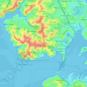
Name: Birkenhead topographic map, elevation, terrain.

Location: Birkenhead, Kaipātiki, Auckland, 0626, New Zealand (-36.84987 174.68505 -36.76987 174.76505)

Average elevation: 23 m

Minimum elevation: 0 m

Maximum elevation: 111 m

Other topographic maps

Click on a map to view its topography, its elevation and its terrain.

Onepoto Domain

New Zealand > Auckland > Kaipātiki

Average elevation: 16 m

Le Roys Bush

New Zealand > Auckland > Kaipātiki

Average elevation: 30 m

Chelsea Bay

New Zealand > Auckland > Kaipātiki

Average elevation: 27 m

Gear up for your next adventure:

🧢Outdoor Cap - Protective cap for sun and rain during hikes
🦶Anti-Blister Balm - Prevents friction and hotspots during long ascents
🩹Moleskin Blister Pads - Direct protection for painful foot pressure points
Family Camping Tent - Spacious tent suitable for family camping trips
🛶Kayak Dry Bag - Waterproof storage for kayaking adventures

As an Amazon Associate, this site earns from qualifying purchases at no extra cost to you.