
Make a donation
Gear up for your next adventure:
As an Amazon Associate, this site earns from qualifying purchases at no extra cost to you.
Keowee topographic map
Click on the map to display elevation.
Make a donation
Gear up for your next adventure:
As an Amazon Associate, this site earns from qualifying purchases at no extra cost to you.
About this map
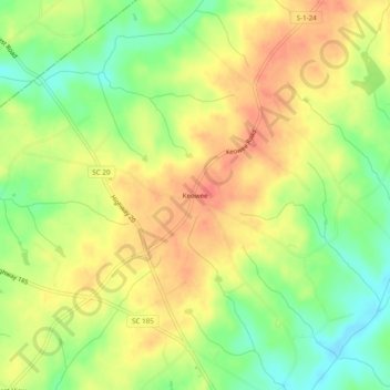
Name: Keowee topographic map, elevation, terrain.
Average elevation: 214 m
Minimum elevation: 184 m
Maximum elevation: 239 m
Make a donation
Gear up for your next adventure:
As an Amazon Associate, this site earns from qualifying purchases at no extra cost to you.
Other topographic maps
Click on a map to view its topography, its elevation and its terrain.
Lake Secession
United States > South Carolina > Abbeville County
Secession Lake is a reservoir on the Rocky River, a tributary of the Savannah River. The spillway elevation is 548 feet (167 m) above sea level. The reservoir extends north into Anderson County, but the CDP consists only of residences built around the lake within Abbeville County. The Antreville CDP borders…
Average elevation: 188 m