Geolocate

Pucking topographic map

Click on the map to display elevation.

About this map

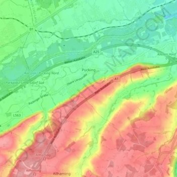
Name: Pucking topographic map, elevation, terrain.

Location: Pucking, Bezirk Linz-Land, Upper Austria, 4055, Austria (48.15759 14.15413 48.20699 14.24500)

Average elevation: 314 m

Minimum elevation: 261 m

Maximum elevation: 375 m

Other topographic maps

Click on a map to view its topography, its elevation and its terrain.

Reith

Austria > Upper Austria > Bezirk Linz-Land > Leonding

Average elevation: 289 m

Reith

Austria > Upper Austria > Bezirk Linz-Land > Leonding

Average elevation: 289 m

Kürnberg

Austria > Upper Austria > Bezirk Linz-Land > Wilhering

Average elevation: 382 m

Holzheim

Austria > Upper Austria > Bezirk Linz-Land > Leonding

Average elevation: 309 m

Wagram

Austria > Upper Austria > Bezirk Linz-Land

Average elevation: 282 m

Gear up for your next adventure:

🧰Multitool Knife - Compact and versatile tool for outdoor use
🧼Biodegradable Camp Soap - Environmentally friendly cleaning for gear and body
🥽Outdoor Goggles - Protective eyewear for outdoor activities
🔋Solar Power Bank - Keep your GPS and devices charged during long outdoor trips
🛏️Sleeping Bag - Warm and compact sleeping bags for outdoor camping

As an Amazon Associate, this site earns from qualifying purchases at no extra cost to you.