Geolocate

Lodwar topographic map

Click on the map to display elevation.

About this map

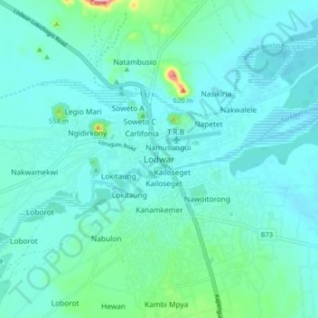
Name: Lodwar topographic map, elevation, terrain.

Location: Lodwar, Turkana County, Rift Valley, 30500, Kenya (3.07659 35.56229 3.15659 35.64229)

Average elevation: 509 m

Minimum elevation: 485 m

Maximum elevation: 659 m

Other topographic maps

Click on a map to view its topography, its elevation and its terrain.

Kokuselei

Kenya > Turkana County

Average elevation: 581 m

Kalokol

Kenya > Turkana County

Average elevation: 379 m

Kakuma Town

Kenya > Turkana County

Average elevation: 611 m

Lokitaung

Kenya > Turkana County

Average elevation: 771 m

Lokichogio

Kenya > Turkana County

Average elevation: 648 m

Kakuma Town

Kenya > Turkana County

Average elevation: 611 m

Gear up for your next adventure:

🔭Outdoor Binoculars - Lightweight binoculars for birdwatching and hiking
💡Compact LED Flashlight - Powerful and portable flashlight for outdoor use
👟Trail Running Shoes - Agile footwear for fast-paced topographic exploration
🥾All-Terrain Hiking Boots - Versatile boots for varied hiking conditions
🥾Hiking Leggings - Comfortable leggings for outdoor activities

As an Amazon Associate, this site earns from qualifying purchases at no extra cost to you.