Geolocate

Emily topographic map

Click on the map to display elevation.

About this map

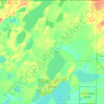
Name: Emily topographic map, elevation, terrain.

Location: Emily, Crow Wing County, Minnesota, 56447, United States (46.71656 -94.02992 46.80365 -93.90266)

Average elevation: 393 m

Minimum elevation: 377 m

Maximum elevation: 422 m

Other topographic maps

Click on a map to view its topography, its elevation and its terrain.

Ruth Lake

United States > Minnesota > Crow Wing County > Emily

Average elevation: 391 m

Gear up for your next adventure:

🪑Insulated Seat Pad - Protect your seat from cold rocks and wet logs
🧦Hiking Socks - Moisture-wicking and comfortable socks for long hikes
🪜Heavy Duty Carabiners - Multi-use clips for securing gear to your backpack
🩹Compact First Aid Kit - Pre-packed essentials for common trail injuries
🛌Insulated Sleeping Pad - Critical thermal barrier between you and the cold ground

As an Amazon Associate, this site earns from qualifying purchases at no extra cost to you.