Geolocate

Portalet topographic map

Click on the map to display elevation.

About this map

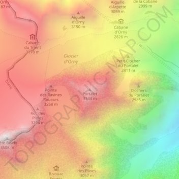
Name: Portalet topographic map, elevation, terrain.

Location: Portalet, Orsières, Entremont, Wallis, Switzerland (45.99156 7.05602 45.99166 7.05612)

Average elevation: 2,864 m

Minimum elevation: 2,029 m

Maximum elevation: 3,484 m

Other topographic maps

Click on a map to view its topography, its elevation and its terrain.

Val Ferret

Switzerland > Wallis > Entremont > Orsières

Average elevation: 2,026 m

Gear up for your next adventure:

🧰Emergency Multi-Tool - Compact multi-tool for outdoor survival
Tent Footprint - Protect tent floor and increase durability
🔨Vehicle Emergency Tool - Safety tool for remote road trips to trailheads
🥾Hiking Leggings - Comfortable leggings for outdoor activities
🧊Insulated Water Bottle - Keeps drinks cold in summer and prevents freezing in winter

As an Amazon Associate, this site earns from qualifying purchases at no extra cost to you.