Geolocate

Bastar topographic map

Click on the map to display elevation.

About this map

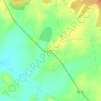
Name: Bastar topographic map, elevation, terrain.

Location: Bastar, Bastar Tahsil, Bastar, Chhattisgarh, 494223, India (19.18929 81.91264 19.22929 81.95264)

Average elevation: 558 m

Minimum elevation: 538 m

Maximum elevation: 586 m

Gear up for your next adventure:

🥾Light Trekking Boots - Supportive boots for multi-day treks
🕶️Polarized Sunglasses - Reduces glare from snow and water at high elevations
🧴Insect Repellent - Protect yourself from bugs during outdoor adventures
🦶Hiking Shoe Insoles - Added support for high arches and long days on feet
🐕Hiking Dog Pack - Let your canine companion carry their own water and food

As an Amazon Associate, this site earns from qualifying purchases at no extra cost to you.