
Reynier topographic map
Click on the map to display elevation.
About this map
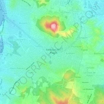
Name: Reynier topographic map, elevation, terrain.
Average elevation: 47 m
Minimum elevation: -1 m
Maximum elevation: 196 m
Other topographic maps
Click on a map to view its topography, its elevation and its terrain.
Île du Petit Gaou
France > Provence-Alpes-Côte d'Azur > Var > Six-Fours-les-Plages > Le Brusc
Average elevation: 4 m
83140
France > Provence-Alpes-Côte d'Azur > Var > Six-Fours-les-Plages > Reynier
Average elevation: 38 m
La Seyne-sur-Mer-2
France > Provence-Alpes-Côte d'Azur > Var > Six-Fours-les-Plages
Average elevation: 28 m
Île du Grand Gaou
France > Provence-Alpes-Côte d'Azur > Var > Six-Fours-les-Plages > Le Brusc
Average elevation: 3 m
Île des Embiez
France > Provence-Alpes-Côte d'Azur > Var > Six-Fours-les-Plages > Le Brusc
Average elevation: 2 m