
Make a donation
Gear up for your next adventure:
As an Amazon Associate, this site earns from qualifying purchases at no extra cost to you.
Le Goëland topographic map
Click on the map to display elevation.
Make a donation
Gear up for your next adventure:
As an Amazon Associate, this site earns from qualifying purchases at no extra cost to you.
About this map
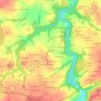
Name: Le Goëland topographic map, elevation, terrain.
Average elevation: 67 m
Minimum elevation: 16 m
Maximum elevation: 100 m
Make a donation
Gear up for your next adventure:
As an Amazon Associate, this site earns from qualifying purchases at no extra cost to you.
Other topographic maps
Click on a map to view its topography, its elevation and its terrain.
Dolo
France > Bretagne > Côtes-d'Armor > Jugon-les-Lacs
La superficie de la commune est de 1 188 hectares. L'altitude moyenne est d'environ 50 m. Quatre rivières la traversent : la Rosette, la Rosaie, la Rieule et l'Arguenon. L'étang du Lou, situé à côté du manoir du Lou, est un site notable en Bretagne.
Average elevation: 62 m