Geolocate

Prado topographic map

Click on the map to display elevation.

About this map
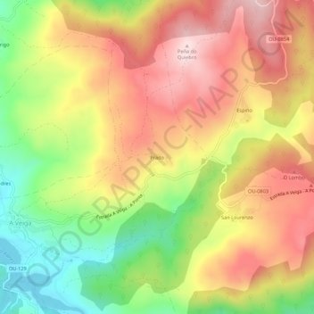
Name: Prado topographic map, elevation, terrain.

Location: Prado, La Vega, Valdeorras, Ourense, Galicia, 32366, España (42.23910 -7.02251 42.27910 -6.98251)

Average elevation: 1,022 m

Minimum elevation: 835 m

Maximum elevation: 1,185 m

Other topographic maps

Click on a map to view its topography, its elevation and its terrain.

Prada

España > Galicia > Valdeorras > La Vega

Al sur, el embalse (altitud media 861 m y bajo sus aguas la antigua parroquia y lugar de Alberguería que estaba a 817 m) y a 11 km por carretera, la capital del municipio, La Vega.

Average elevation: 1,075 m

Lamalonga

España > Galicia > Valdeorras > La Vega

Average elevation: 1,274 m

Valdín

España > Galicia > Valdeorras > La Vega

Average elevation: 1,263 m

Castromarigo

España > Galicia > Valdeorras > La Vega

Average elevation: 924 m

Gear up for your next adventure:

🔥Emergency Fire Starter - Reliable ignition source for all weather conditions
🧢Beanie Hat - Keep your head warm in cold weather
🧭Orienteering Kit - Tools for map reading and navigation in the wild
🔋Lithium AA Batteries - Long-lasting power that performs in extreme cold
🎒Fully Waterproof Backpack - Total protection for photography gear and electronics

As an Amazon Associate, this site earns from qualifying purchases at no extra cost to you.