Geolocate

Ventanas topographic map

Click on the map to display elevation.

About this map

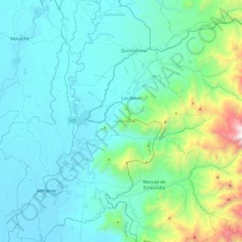
Name: Ventanas topographic map, elevation, terrain.

Location: Ventanas, Los Ríos, Ecuador (-1.52804 -79.55199 -1.12280 -79.26748)

Average elevation: 386 m

Minimum elevation: 12 m

Maximum elevation: 2,682 m

Other topographic maps

Click on a map to view its topography, its elevation and its terrain.

Los Cedros

Ecuador > Los Ríos > Vinces > Vinces

Average elevation: 25 m

Pepa De Oro

Ecuador > Los Ríos > Puebloviejo > Puebloviejo

Average elevation: 14 m

La Fortuna

Ecuador > Los Ríos > Quinsaloma > Quinsaloma

Average elevation: 94 m

Sam Augustin

Ecuador > Los Ríos > Valencia > Valencia

Average elevation: 103 m

Patria Nueva

Ecuador > Los Ríos > Vinces > Vinces

Average elevation: 16 m

Galapagos

Ecuador > Los Ríos > Mocache > Mocache > Galapagos

Average elevation: 59 m

Gear up for your next adventure:

🥾Waterproof Hiking Shoes - Durable shoes for wet and rugged trails
🥾Mountain Hiking Shoes - Shoes with superior grip for mountainous terrain
🪜Heavy Duty Carabiners - Multi-use clips for securing gear to your backpack
🧭Orienteering Kit - Tools for map reading and navigation in the wild
🧥Packable Rain Jacket - Breathable waterproof layer for unpredictable weather

As an Amazon Associate, this site earns from qualifying purchases at no extra cost to you.