Geolocate

Chucuní topographic map

Click on the map to display elevation.

About this map

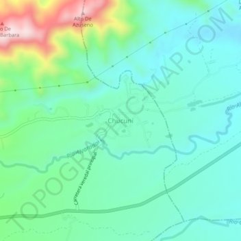
Name: Chucuní topographic map, elevation, terrain.

Location: Chucuní, Ibagué, Centro, Tolima, Colombia (4.44622 -75.07611 4.48622 -75.03611)

Average elevation: 745 m

Minimum elevation: 639 m

Maximum elevation: 1,076 m

Gear up for your next adventure:

🥾All-Terrain Hiking Boots - Versatile boots for varied hiking conditions
🌡️Emergency Mylar Blankets - Compact thermal protection for unexpected nights outdoors
🗺️Topographic Maps - Detailed maps to explore trails, mountains, and wilderness areas
🥾Durable Hiking Shoes - Long-lasting shoes for frequent hiking
🧥Ultralight Puffy Jacket - Maximum warmth that packs down to the size of an orange

As an Amazon Associate, this site earns from qualifying purchases at no extra cost to you.