
Make a donation
Gear up for your next adventure:
As an Amazon Associate, this site earns from qualifying purchases at no extra cost to you.
Djanet topographic map
Click on the map to display elevation.
Make a donation
Gear up for your next adventure:
As an Amazon Associate, this site earns from qualifying purchases at no extra cost to you.
Djanet
Djanet est située à l'est de l'erg Admer, au nord-ouest de la Tadrart Rouge, et au pied du plateau du Tassili N'Ajjer, à une altitude de 1 050 m. Elle est traversée par l'oued Idjeriou (signifiant la mer) qui permet d'alimenter sa palmeraie. Elle est un axe important de communication de liaison avec Ghat en Libye voisine.
Make a donation
Gear up for your next adventure:
As an Amazon Associate, this site earns from qualifying purchases at no extra cost to you.
About this map
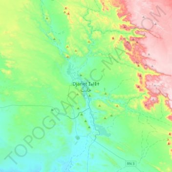
Name: Djanet topographic map, elevation, terrain.
Location: Djanet, Daïra de Djanet, Djanet, Algérie (24.39388 9.32419 24.71388 9.64419)
Average elevation: 1,209 m
Minimum elevation: 975 m
Maximum elevation: 1,808 m
Make a donation
Gear up for your next adventure:
As an Amazon Associate, this site earns from qualifying purchases at no extra cost to you.
Other topographic maps
Click on a map to view its topography, its elevation and its terrain.